
Thank you Scott and Kathleen for getting married kinda close to the Winds.

My wife and I in wedding mode. I had the trip of a lifetime but missed you dearly. Thanks babe!

Let me introduce my hiking partner Fred C. When not walking in the mountains he...
Teaches physics at a local college.

Races CX AND crushes all comers for Chica Sexy.


Oh ya... he also walked the PCT and the CT. Wow.
The basics:
-8 days of awesome starting at Elkheart and a dirty, happy finish at Big Sandy trailhead . We used the shuttle services of The Great Outdoor Shop in Pinedale. Highly recommended.
-Inspiration came from the great BPL explorer Andrew Wolff his trip report here.
-Maps used:
General planning, Wind River Range Outdoor Recreation Map 1:100,000 by Bearthooth Publishing.
Off trail routes, custom maps at scale 1: 24,000 created with MyTopo.
-Books used:
Beyond Trails by Nancy Pallister. A FANTASTIC guide book published by Grey Dog Press. This is a must read for anyone entertaining the idea of off trail travel in the Winds.
Wind River Trails by Finis Mitchell. The old school guide and WRR bible. Mitchell is responsible for stocking most if not all of the WRR lakes in the 30's. It feels and reads like a collectors item but proved to be useful as well. Highly recommended.
-Navigation equipment
iPhone preloaded with USGS 7.5 quads in the app Topo Maps.
Ancient Silva Ranger w/sighting mirror from Boy Scouts no less.
A promise to each other to use our brains, be safe and most important cautious. Nobody was trying to prove anything on this trip.
-Mosquito level scoring 1 - 10. 1 being none at all (woo hoo!). 5 kinda sucks being outside but whatever. 7 totally sucks but doable w/head-net, bite proof clothing, and a gallon of UltraThon. 10 you are emotionally scarred and take up another recreational pursuit.
** Note ** I'm a idiot, threw a last minute fit and decided shelters w/floors are bogus. Instead of my Tarptent Moment (awesome) I brought my GoLite Shangri-La 2 (equally awesome but...) w/no mesquito netting perimeter. DUMB! Fred being a gentleman let me squeeze into his tarp w/netting on the two worst nights for bugs. Thx Fred!!
** Warning ** This trip report to some could be torture, like watching an incredibly bad surfer ride the most beautiful wave you have ever seen. For people who understand the rules of grammar and/or don't want their artistic sensibilities shattered with my sophomoric attempt at photography I will sum up summer hiking in the Winds with a simple mathematic equation.
(Sierra's + Weather) - Crowds = Wind River Range
Day 1
Mosquito level 4.
We predictably got a late start from Jackson Hole WY but eventually made it to the trailhead around 6pm. The road up to Elkheart trailhead from Pinedale is in good shape and easy for any make of vehicle. I drive a VW Golf TDI with almost no clearance and could easily high side on a pebble.
Fred and I at the trailhead all stoked to go hiking. Notice my plastic adventure clothing, a first for me. I was surprised how well it all worked and will be using everything again for future trips. Fred used his girlfriends pack! Some ancient bomber w/huge aluminum stays that weighed a ton but shrugged off the heavy load (10 days of food) with aplomb.

We arrived at Photographers Point at dusk, enjoyed the view and alpenglow while swatting mosquitos. Both Fred and I stated a desire to have this trip be more about the journey and less about the destination. Since this is a foreign concept we were a little shaky about the lack of miles but stuck to our guns and camped aprx 1/4 mile beyond off in the trees. Who needs to hike in the dark for some arbitrary milage number anyway... Not us we proclaimed!
Day 2
Mosquito level 6
Random spot in bushes near Photographers Point to West of Knapsack Col above Peak Lake. Via Seneca Lake and Highline trails to Shannon Pass trail.
Today was a trail burn but WOW what a trail burn it was. Soon after Photographers Point you reach the alpine environment and things improve dramatically. We blasted along chatting with the various groups of people we saw, this is a busy area of the WRR and we crossed paths w/other people along the trail every hour or so.
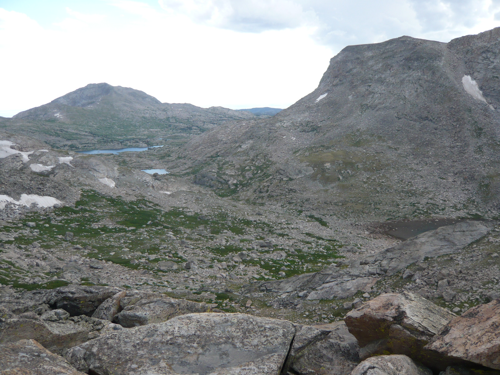
A view of Peak Lake from the top of Shannon Pass. We followed a use trail on the North side of the lake and started our ascent of the gentle valley leading to Knapsack Col.

Knapsack Col is hidden by the hills on the left side of frame, Winifred peak in center. You can see how mellow this valley is we found a great spot to camp and called it a day. Pallister warns that you must do your mountain passes in the morning the Winds are unpredictable with gnarly weather not uncommon especially afternoon thunderstorms. Unbeknown to us fate had a lesson in store more on that later. We planned an early start for Knapsack Col...

Day 3
Mosquito level 7
Knapsack Col to Wall lake area. Knapsack Col, Titcomb Basin, Island Lake, between Mt Lester/Elephant Head.
The ascent to Knapsack Col is obvious and although steep nothing remarkable, the view is awesome!
Our friends gave out bandannas at their wedding and we couldn't resist. The view behind us is looking West.
We had coffee and treats in an attempt to linger and feel the journey. It worked.

Another view from the top of Knapsack Col looking west with Peak lake middle at the bottom other lakes are unnamed on the way up the valley.

We had to jog left avoiding steep snowfields on the East side of Knapsack Col. The boulder field was intense for a short while but mellowed out quickly. Titcomb Basin was visible the entire time and route finding was super easy.

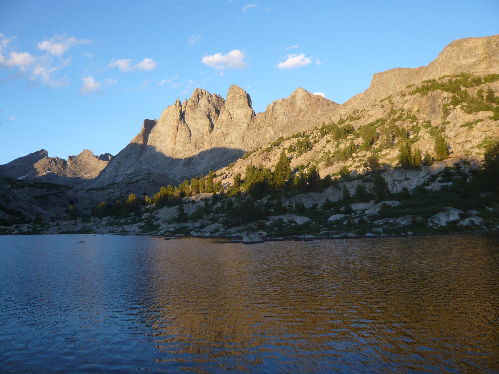
Obligatory Titcomb Basin shot. The TB is beautiful but crowded. We enjoyed the scenery motoring thru towards are next off trail portion. This shot is at the beginning of the first big lake looking down the basin.

From the Titcomb Basin our plan was to head into the Indian Basin and then overland thru a pass between Elephant Head and Harrower Peak towards the Wall Lake area. But... for whatever reason our energy was low and instead we followed the inlet waterway of Island Lake up into the same zone. The hiking was easy as the Island Lake inlet valley has a gentle slope and is a fantastic route for accessing Wall Lake.
Our camp for the night was above a small lake at aprx the 11,000 foot contour line dead center of our little valley. We saw evidence of people from a use trail in the lower part of the valley but saw no one between Island and Wall lakes. A dramatic sunset w/just enough wind to eradicate the mosquitos for the night.

How NOT to hang your food. Dumb as a box of hammers! With no trees in sight we got really lazy and hung our food just high enough that a bear would have to stand on it's hind legs. Incidentally we saw NO evidence of bears the entire time in the WRR, plenty of elk scat and sightings though.

Day 4
Mosquito level 5
Island Lake inlet valley to above Upper Golden Lake. Wall Lake, Cook Lakes, Bald Mountain Basin, unnamed pass North of Angel Peak.
A fantastic morning full of sunshine, flowers, and incredibly beautiful mountain country. Below Fred navigates the terrain above Wall Lake. A walk in the park!


After Wall Lakes we regained the trail briefly before heading off into the Bald Mountain Basin staying high above Spider Lake. The Basin is relatively flat w/easy walking, below you can get an idea of the terrain. Angel Peak is center w/ the Angel Pass to the right. We trended towards the left or North to an unnamed lake and pass for access to the terrain above Upper Golden Lakes.

Just North of Angel Peak nestled in a steep walled canyon is a lake and right before the outlet of the lake you can see a steep somewhat sketchy way up and over towards the East. We started up this around 2pm w/clouds beginning to form up. Duhh... Half way up hanging on to clumps of grass and scrabbling our way higher thunder started to BOOM above us. It didn't take any guessing what was about to happen and we scurried down the way we had come. Within minutes it began to hail with thunder and lighting snapping on the peaks above. Pheww! Once safely down we quickly threw up my shelter and dove inside to wait out the storm. Fred waving at the start of our climb prior to weather turning us back.


** Note ** Just as Andrew had mentioned in his crossing of this pass you can get cell service here. We fired up the iPhone and called our significant others for a brief hello. Being super comfortable and not really wanting to leave this fantastic spot we decided to have an early dinner.
I'm wearing a new pair of Montrail Machosist shoes which I really liked. If you have narrow feet such as I do you might give them a try. Also I am compelled to give a shout out to my Patagonia Houdini. I love you Houdini! The Houdini is hands down the most versatile piece of fancy plastic adventure wear I own. Love it...

Eventually we packed up and walked NEish a short distance to where we decided to camp just above and West of a small unnamed lake above the lakes draining into Upper Golden Lake. We slept at about the 11,500 contour line near the Continental Divide.
It proved to be a cold and windy night and I tossed and turned for most of it. Fred had a equally fitful night and we awoke at dawn to get an early start.
Our campsite is just below the small snowfield in the bottom of this picture the lakes pictured drain down towards Upper Golden Lake

No bugs up here and I was comfortable in my GoLite SL-2. Because of occasionally powerful gusts I secured the leading edge. I find it easier to sleep when I know my shelter is secured well, nothing to worry about when you hear the wind coming shrieking down the canyon towards you.

Fred makes all his own camping stuff. This tarp served him well on the CT and shrugged off everything the Winds hurled at it as well.

All nestled in for the night.

Brief side note about our route choice. Looking at the map and remembering the terrain I see that accessing the same area could be easily done from the Wall lake side instead of going around and thru the Bald Mountain Basin. The unnamed lake just below the peak labeled 12529 (Beartooth map) in the Wall Lake drainage shows the start of what looks to be another way up and over towards the Golden Lake area. Yet another example of how flexible much of the travel above tree line is in the WRR. Lots of options everywhere you look.
Day 5
Mosquito level 3 maybe... Things are looking up!
I crack in the morning and Fred has to talk me off the ledge. No shit... with little sleep and super buzzed on Via I kinda lose it eventually coming around to a what we are generously calling a "mountain epiphany." Fred thanks for the calm voice of reason and more coffee. Hugs bro!
The route down towards Upper Golden Lake is game on with plenty of boulder hopping and a few tight spots with what felt like bouldering. Just stay to the left side of all the little lakes and everything will be cool. The Golden Lake area is probably the most remote area we hiked in during this trip and it felt like it. Once down to the lakes proper a slight use trail shows itself on the right or West side of the lakes. Both of us really wanted to head North up and over an imposing pass towards Douglas Peak and the Alpine Lakes area. But alas without the proper maps we stayed on course and headed towards Dennis Lake and Hay Pass.
Looking South towards the top of Upper Golden Lake.

Looking North back towards the Golden Lakes with the pass leading to Douglas Peak and Alpine Lakes in the distance center of picture. Next time!

Hay Pass was SUPER WINDY we regained the trail on the South side after crossing the Continental Divide. Fred had a cool idea and we immediately headed SEish in to a wide, flat valley to the North and East of Mt Victor heading towards the Europe Canyon Trail. A unnamed lake (stay to the left) snuggled up to Mt Victor turned out to be my favorite of the entire trip. A superb campsite area exists at the outlet of this lake with amazing views and spectacular rock formations looming overhead from Mt Victor. If I ever bring my wife to the Winds we will camp at this spot for sure! Here we are looking South at the beginning of the lake luckily we decided to go left and didn't have to backtrack. The right side cliffs out quickly.

We walked thru the easy to navigate and obvious pass near the outlet and hit the Europe Canyon Trail just in time to set up camp and have a quick swim and dinner before it got dark.
Day 6
What's a mosquito? No shit! From here on out we didn't see or hear another mosquito.
Europe Canyon to Bonneville Basin Lakes. Via the Fremont Trail and a use trail following the Bonneville Basin creek up to the lakes.
We trail burned the Fremont Trail to Bonneville Basin creek and although beautiful country I found it tiresome. I know! What a whiner and you would be right but after being in higher country for a few days it's hard to go back into the trees. Eventually we reach Bonneville Basin creek where it drains into Raid Lake and follow a use trail up to the third small lake (Beartooth map) of the Bonneville Basin. From here we plan a alpine start to get over the pass between Raid Peak and Mt Bonneville.
below you see what we will be climbing the next day. Raid Peak is center right.

Mt Bonneville with the beginnings of alpenglow from near our campsite.
Our first mountain top! This view is looking North towards the toothy spires of Mt Bonneville and beyond.

Fred and I stoked to be up top on such a bluebird day.

I don't know why they call him Gentle Fred the dudes a total daredevil. Here he peers down a few thousand feet to the valley below.

We bumped into a BPL'er on a 14 day hike thru the winds and chatted over tea and cookies in the pass enjoying the mountain air and each others company.
Eric I trust the rest of your trip went well. I especially liked your tale of meeting Pallister while hiking a remote section of the Winds. Very cool...
Eric gave us a good idea and instead of grabbing the trail at the bottom of Pyramid Lake he suggested taking the small (but intense!) walk thru the valley above Pyramid Lake towards Hailey Pass. I'm not sure if you can call it a valley, probably not, but you catch Hailey Pass by passing both Pyramid Lake and Pyramid Peak just to the North. Way better! Thx Eric.
You can kinda see what I'm talking about here. Pyramid Lake in center with Pyramid Peak just above.

We swam in a unnamed lake prior to Pyramid Lake. The dudes with the goofy tan lines! Thats what you get for being a die hard cyclist. Bike undies make you look funny both clothed and unclothed.

From Hailey Pass we bid the wild country goodbye and joined the masses on trail with a trail burn to Valentine Lake for our nights rest. A nice walk, if a little dusty, and a fun change to see people and chat on the trail. Lots of spectacular granite walls I'm sure the climbers who get in this far are rewarded mightily.
A crappy shot of Mt Hooker to give you an idea.

And a slightly better shot of Payson Peak. Dudes must freak out when they see this stuff and know they have all to themselves.

Again we were tempted by the awesome terrain we could see from Valentine Lake. A decent looking route from the South Fork Lakes into the Bear Lake area looked doable from our Beartooth map. But we had promised ourselves caution and again without a more detailed map we headed for the Lizard Head Plateau trail. Both of us embolden with our previous route finding adventures and newly gained love of off trail travel loathed to grind out the miles on a trail. But... we didn't have the proper maps and good judgment prevailed.
Off we set for another day of trail pounding towards the Cirque of the Towers. Curiously the Lizard Head Plateau Trail proved to be really cool and I'm glad we hiked it. A strange empty land with weird rocks sprouting out of the earth and an odd sort of vibe to the entire place.
I kept thinking of 60's era Star Trek and half expected an extra wearing yellow corduroy pants, a burgundy sweater, and a metal bucket on his head to leap our from a rock and take me as a hostage. Ya it was that strange...


We lolled around for most of the day staring at Pingora Peak in awe while soaking our tired feet in Lonesome Lake. Towards evening we climbed up to Jackass Pass and set up camp for some SICK alpenglow on the Cirque. I was too stoned out on nature to remember my camera but it was a show for sure.
This dude is HIGH on nature! Needless to say I slept soundly and had a spring in my step the next morning. Visions of a huge salad and a milkshake waiting in Pinedale danced in my head.

With the last light I remembered my camera, a shot from my cowboy camp sleep spot.

Then it got dark.

We blasted down from Jackass Pass in the early morning and arrived at the Big Sandy Trailhead tired, dirty and in good spirits. The trip was a success in every way and both Fred and I are better people after traveling thru the Wind River Range. Thank goodness for wilderness!
**Little known secrect** Pinedale Aquatic Center has showers w/unlimited hot water and soap for $5.00 plus if you want you can use the rest of the facilities like... the WATER SLIDE!!
We ate at this crazy place called the Rock Rabbit Cafe on main street in Pinedale. Don't let all the hippie paraphernalia scare you the coffee is good and food top notch.
Gear grind.
I used a cat can stove w/windscreen which worked well but sucked compared to Freds set up. Below is a picture of his cooking rig. Homemade pepsi can stove I recall the pot stand being made from bicycle spokes, windscreen from MSR.


And all bundled up.

I'm using a Montebell #3 sleeping bag and don't really like it I have about 40 nights in it. Not enough for a proper gear review but enough for me to get a feel for the bag and experiment with various options, liner, long underwear, etc. The fact is that with two more ounces of down in the top this bag would be best in it's class. But... it has way to many cold spots plus the lack of a draft tube means you feel the wind. For sure the most comfortable bag I have ever slept in but thumbs down. Seen below with current sleep set up minus a Tyvek ground cloth.

Two quick things and then I'll stop.
1. I now have a rip roaring set up for bugs.
UltraThon. Awesome! Does not leave you feeling greasy, nauseous, or smelling that Deet smell...
Peters headnet. This is the real deal from a pro. Check him out here.
Patagonia Houdini. Impenetrable to bugs and just downright fantastic.
All shelters have bug netting. GoLite SL2 netting mod done by BearPaw. Site here.
2. Having to be super careful w/my inflatable pad sucked. I really missed being able to just flop down on my foam pad whenever we took a break, etc. Thinking that I'll head back to a Thermarest Z Lite and see if I can still hack it. Ha! We'll see about that huh..?
Parting shot of my fantastic hiking partner. Dude your rad.

Mountains!


